|
Air Masses
An air mass is a large body of air with relatively uniform characteristics (temperature and humidity) in the horizontal. Properties The properties of an air mass depend upon: a) its source – air originating in tropical regions is warm, whereas air originating in polar regions is cold. b) Its track – air travelling over the sea is moistened, whereas the moisture in air with a continental track is hardly changed. Southward moving air is warmed from below and becomes more unstable, whereas northward flowing air is cooled from below and becomes more stable. The large scale vertical motion in a depression encourages the development of showers in southward moving air, whereas in the vicinity of an anticyclone the subsidising air tends to suppress showers. 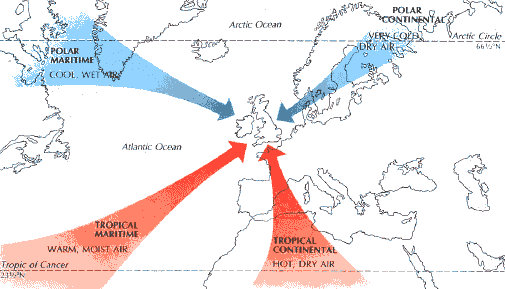
|
|
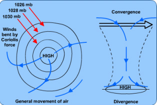
Anticyclones - Are high-pressure areas of descending or stable air. They originate in the upper atmosphere where conditions are dry. Winds are gentle and blow clockwise, skies clear, and temperatures high in summer months. In the UK they can act to 'block out' other weather systems, such as depressions bringing fine, settled weather for several days.
Winter anticyclone: Clear skies, low temperatures (little Insolation) fog and frost can be common. Some snowfall on the east coast. Summer anticyclone: Clear skies, little rain, high temperatures (much insolation) fog and temperature inversions. If heating is intense enough thunderstorms can result. |
|
|
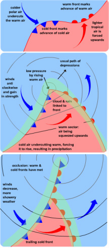
Depressions
These are one of the most common weather systems to affect the UK. They last for 2-3 days, cross the UK from west to east. They are areas of low pressure, bringing strong winds, cloud and rain. Stages in a depression The information in the table below corresponds to the three subsequent diagrams: 1 Embryo Starts as 'wave' on the Polar front, where moist, warm Tm air meets drier, colder more stable Pm air. The warm, moist air is forced aloft, by the colder denser air, creating low pressure. 2 Mature Pressure falls further and the distinctive cold and warm sector and warm front are clearly recognisable. Winds become stronger, clouds develop, and precipitation occurs. Rainfall is steady at the warm front where warm air rises slowly over cold air. It is heaviest at the cold front due to the rapid rising of the air. 3 Decay The faster moving cold front has caught up with the warm front reducing the warm sector and creating an occluded front. Condensation is reduced as smaller amounts of air are forced aloft. |
